The handy guide to Publishing in Geography by RGS-IBG and Wiley-Blackwell.
Via Very Spatial.
Wednesday, September 24, 2008
Friday, August 22, 2008
Vipers and Vampires: Measuring Oil Vulnerability
Had a very interesting visitor yesterday: Jago Dodson from the Urban Research Program at Griffith University in Australia. Jago has published research on measurement of Oil Vulnerability in Australian cities eg:
Oil Vulnerability in the Australian City: Assessing Socioeconomic Risks from Higher Urban Fuel Prices (Dodson and Sipe, 2007)
Shocking the Suburbs: Urban Location, Housing Debt and Oil Vulnerability in the Australian City (Dodson and Sipe, 2006)
Oil vulnerability is measured by combining various census variables (mode of transport to work, number of cars in a household) and socioeconomic data (SEIFA) to produce the VIPER (Vulnerability Index for Petrol Expense Rise).
The VAMPIRE (Vulnerability Assessment for Mortgage,Petrol and Inflation Risks and Expenditure) is a measure of oil and mortgage vulnerability and includes mortgage information.
I decided to try this for a NZ city. Here is a quick lo-res attempt at an Auckland VIPER:
[caption id="attachment_28" align="alignnone" width="300" caption="VIPER index from 2006 census data. Dark = more vulnerable to oil price increases. Light = less vulnerable."]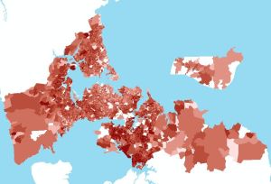 [/caption]
Now I just need to find some mortgage data, cause even though VIPER is a pretty cool name, I love the idea of creating a VAMPIRE index!
Oil Vulnerability in the Australian City: Assessing Socioeconomic Risks from Higher Urban Fuel Prices (Dodson and Sipe, 2007)
Shocking the Suburbs: Urban Location, Housing Debt and Oil Vulnerability in the Australian City (Dodson and Sipe, 2006)
Oil vulnerability is measured by combining various census variables (mode of transport to work, number of cars in a household) and socioeconomic data (SEIFA) to produce the VIPER (Vulnerability Index for Petrol Expense Rise).
The VAMPIRE (Vulnerability Assessment for Mortgage,Petrol and Inflation Risks and Expenditure) is a measure of oil and mortgage vulnerability and includes mortgage information.
I decided to try this for a NZ city. Here is a quick lo-res attempt at an Auckland VIPER:
[caption id="attachment_28" align="alignnone" width="300" caption="VIPER index from 2006 census data. Dark = more vulnerable to oil price increases. Light = less vulnerable."]
[/caption]Now I just need to find some mortgage data, cause even though VIPER is a pretty cool name, I love the idea of creating a VAMPIRE index!
Monday, July 7, 2008
One conference down: three more to go
Went to NZ Geographical Society conference last week. Report to follow. But I will say it was freezing and that I bought ear muffs from Spacesuit.
Now I only have 3 more conferences to go to this year:
One a month. And I have to present at all of them. Ick! I still hate presenting. The people who say "it gets easier" are wrong.
Now I only have 3 more conferences to go to this year:
- Walking 08
- Geocart/SIRC 08
- NZ ESRI User conference
One a month. And I have to present at all of them. Ick! I still hate presenting. The people who say "it gets easier" are wrong.
Health and The Built Environment Seminar
Yesterday Reid Ewing, a Research Professor at the National Center for Smart Growth, visited SHORE and gave a talk that touched on various aspects of the relationship between the Built Environment and Public Health.
He talked about the sprawl index they developed, which is comprised of: low density, highly segregated land use, lack of centering, and poor street connectivity. Low accessibility is also a characteristic of sprawl.
Sprawl has been linked to outcomes like: increased VMT (Vehicle Miles Traveled), worse air quality, climate change, and traffic safety.
Climate change and traffic safety were new ideas things for me.
Reid also mentioned the 6 "D" variables that influence travel at the meso and micro scale: Density, Diversity, Design, Demographics, Distance to transit, and Destination accessibility.
Some of those D's are relatively straightforward. Design is more complicated to measure but the key point is that "human scale" design is good.
A very interesting comment that Reid made was that Destination accessibility is the most important variable in terms of VMT. This relates to the CO2 project ie my model which measures change in accessibility under different transport scenarios.
Friday, June 6, 2008
things that get in the way of doing research: new computers
A new computer is a good thing. Mostly. However, it takes a large chunk of time to reinstall everything and copy stuff. I have installed the essentials: FF, zotero, ArcGIS, assorted ArcGIS extensions and backup software. But I still have a lot more to install: SAS, SPSS, Google Earth, Dreamweaver, random other GIS type apps.
The other thing about new computers is that they often start doing weird stuff. Like going blank temporarily.
I knew all this, so I ordered the new computer months ago so that it would arrive before the busy season. But it was slow to arrive and so it arrived right in the middle of the busy season.
The other thing about new computers is that they often start doing weird stuff. Like going blank temporarily.
I knew all this, so I ordered the new computer months ago so that it would arrive before the busy season. But it was slow to arrive and so it arrived right in the middle of the busy season.
Thursday, June 5, 2008
lost things - I want to track articles
I keep losing articles. Usually the most important articles. And no matter how organised I am with my citation management (woohoo zotero!) it still doesn't know where I last put the paper copy. Is it in the office? Is it at home? Did I leave it on the bus? I don't know! And, yes, I could print out another copy, but I usually scrawl profound notes on the important articles.
I need tiny tracking devices. Pretty colour-coded stickers would be ideal. Linked to my online citation manager. Then when I lose an article I can go look at a map and see exactly where it is. That'd be cool. It'd be even cooler if I could zoom in to see a map of the piles of paper on my desk and I could see exactly where in the piles of paper the article is.
I need tiny tracking devices. Pretty colour-coded stickers would be ideal. Linked to my online citation manager. Then when I lose an article I can go look at a map and see exactly where it is. That'd be cool. It'd be even cooler if I could zoom in to see a map of the piles of paper on my desk and I could see exactly where in the piles of paper the article is.
Thursday, May 8, 2008
Wednesday, April 30, 2008
when I am lonely the mountains call me
What a cool paper name! How could I resist tracking down and reading an article entitled "When I am Lonely the Mountains Call Me": The Impact of Sacred Geography on Navajo Psychological Well Being?
I came across it while googling "wellbeing" and "geography." And it took quite a long time to find an electronic version of the paper, which is very unusual. Most things are at the tips of my fingers and available within seconds. But this took around 45 minutes to track down. Of course I was also multitasking and doing other things at the same time.
Anyway. You can find the pdf here at the National Center for American Indian and Alaska Native Mental Health Research.
As a result of the difficulty in tracking down this somewhat obscure article I have started a list of journal links. I think I will only add the obscure and less easy to find instantly journals though.
And no I haven't read the article yet, but I think it's about homesickness...
Tuesday, April 22, 2008
conference deadlines
Gosh it is busy. Abstract after abstract after abstract...
The Australasian Transport Research Forum 2008 abstract deadline was yesterday. Managed to get something in on time. Although if it gets accepted, then I only have a month to do the analysis AND write the paper. On top of everything else. Hmmm.
The GeoCart 08 paper is due next Monday. Have lots of ideas relating to the Mauri project, perhaps too many, but I haven't written anything, so I think I might have to give the full paper thing a miss, and settle for just an abstract and presentation.
Then the New Zealand Geographical Society 2008 conference abstracts are due the following week. Still thinking about whether to do something for this conference. Maybe two or even three things. That would be efficient. Two birds. One stone.
And all the papers to write as a result. Hmmm... I'm not even going to many conferences this year!
Sunday, April 20, 2008
What to do with old business cards
During the four years in my previous job my company changed it's name once, and changed it's branding four times. So I have piles of old business cards. The other day I discovered a use for them: write down potential paper ideas on the back. This is extremely useful for me cause it seems that whenever I read a paper I frequently get lots of ideas for other papers and/or questions to research in the future. Having paper ideas on small cards is great cause not only do I have a record on them, but I can also lay them out and shuffle them around to organise them.
[gallery]
[gallery]
Wednesday, April 16, 2008
little plane flies through lightning
Yesterday I got to fly in a little plane that was being jostled from side to side almost continuously. Just as well I was still half asleep. But more interestingly, I got to fly in a little plane right through a thunder and lightning storm. "Electrical activity" doesn't look that much different at x-thousand feet than it does at 0-thousand feet, aside from perspective and the just seeming closer thing. But it certainly feels different at altitude.
The pilot said it was perfectly safe. I'm not convinced about that. But it was certainly dramatic.
This is kind of related to research/work in that I sometimes have to fly in planes to do research and work.
The pilot said it was perfectly safe. I'm not convinced about that. But it was certainly dramatic.
This is kind of related to research/work in that I sometimes have to fly in planes to do research and work.
Tuesday, April 8, 2008
Sustainability: Paul Weaver Seminar & NZSSES Conference
I thought about submitting an abstract for this years NZSSES (New Zealand Society for Sustainability Engineering and Science) Conference. It's on "Blueprints for Sustainable Infrastructure". Of course I've never actually studied or researched or read about sustainability in particular. I've just heard the word used everywhere.
So in the interests of a crash course in sustainability I went along to the Paul Weaver lecture on the MATISSE project. Very interesting! And my goodness the seats in the new Business School building are comfortable! Anyway. The lecture which was scheduled for half an hour went on for over one and a half hours!!
Sustainability seems to be an interesting idea. More so because it seems kind of obvious to me, yet it also seems to be a problem and lots of people seem to be very concerned about it and are looking for ways to solve the problem (again it seems obvious, but maybe I'm naive and don't know all the intricacies).
Paul was an interesting and enthusiastic speaker and because it was all new to me, he sparked lots of ideas. I will write about them later.
Anyway, thinking about submitting an abstract for the conference (I didn't) and going to the lecture made me very curious about what all this sustainability fuss is about. My PhD probably relates to it. But then it seems that everything relates to it.
Tuesday, March 25, 2008
Web tools for my PhD: Zotero and others
So I was going to work on my PhD proposal today, but instead I spent the entire day trying to ascertain whether there is a quick and easy way to do a PhD - there isn't. Or if there is, google does not know about it. Although I did come across someone who said that one of his student finished a PhD in 6 months. That is inspiring!
I also spent the day researching web-based research tools to make PhD life easier. I found that although there are lots and lots of research tools, most of them are annoying and do not do exactly what I want them to. Here is what I discovered and decided about research tools:
Citation Manager: Zotero
I decided to use zotero to manage my citations. And maybe syncing to citeulike and connotea in order to take advantage of community/sharing functions that zotero does not have. The main reasons I chose Zotero is that it is the best at easily capturing citations while browsing the web, and it can store associated documents (pdfs, snapshots). In addition, it allows tagging, multiple folders, saved searches, and has a playlist like functionality, and you might almost persuade yourself that you are listening to music. Other good things: it integrates with Word and OpenOffice, it it is open source.
Downsides of Zotero are that the citation database is stored on the local computer (or portable drive). Apparently they have plans to allow online storage, but that hasn't been implemented yet. Also it only works in Firefox and some other browser (not Internet Explorer). And another (minor) problem I have with Zotero is not seeing an ID number associated with each reference. I like to write these on any printouts so I can find them easily.
I think I will buy myself a new flash drive and install portable Firefox and Zotero on it and backup to both computers.
Must be careful to back things up and not overwrite the wrong files.
Working Online: Zoho or Google
Not quite sure on this yet. I am trying out both for writing, note-taking etc. I wonder if anyone has written a PhD in Google Docs? Probably not yet. I think I will have to write the actual PhD in Word, but could use google or zoho for drafts and notes and intermediary bits and pieces. Although the major drawback is that there is no integration with any of the citation managers.
Blog: Wordpress
Why Wordpress? Cause I didn't have a Wordpress blog. Although I do now: who where why. As you can see I don't have a thesis title yet, and the topic needs refining, but I figured whatever I choose it is going to relate to who where and why. And whowherewhy is easier to remember than really-long-convoluted-thesis-title.
Other
I will continue to use:
- gmail for email
- del.icio.us for bookmarks (wonder if it can integrate with Zotero?)
- rememberthemilk for todo lists (integrated with google calendar and twitter)
- google calendar (synced to Outlook)
- twitter for who knows what! I might start a special PhD twitter account though. I am not quite sure how useful twitter will be, but that is no reason not to try and see!
- LinkedIn for networking
Saturday, March 1, 2008
Publications
Papers
Witten K, Huakau J, Mavoa S (forthcoming) Social and recreational travel: The destinations, travel modes, and CO2 emissions of New Zealand households. Social Policy Journal of New Zealand.
Oliver M, Badland HM, Mavoa S, Duncan,MD, Duncan JS (2010). Combining GPS, GIS and accelerometry: Methodological issues in the assessment of location and intensity of travel behaviors. Journal of Physical Activity and Health, 7(1), 102-108.
Badland HM, Schofield GM, Witten K, Schluter PJ, Mavoa S, Kearns RA, Hinckson EA, Oliver M, Kaiwai H, Jensen VG, Ergler C, McGrath L, McPhee J (2009) Understanding the Relationship between Activity and Neighbourhoods (URBAN) Study: research design and methodology. BMC Public Health,v.9
Reports
Mavoa S (2008) Accessibility Model to Measure the Social Impact of Reduced Fuel Consumption Scenarios, SHORE & Whariki, Massey University, Auckland (Objective 3, milestone 8 )
Rose, E, Witten, K, Sweetsur, P, Huakau, J, Mavoa, S, McCreanor, T (2006) Key Social and Environmental Factors that Influence Neighbourhood Walking and Mode Choice in Neighbourhood Utilitarian Trips, Reduced CO2 from Sustainable Household Travel Research Programme Technical Report, Objective 2 Milestone 6, June 2006. Auckland: Centre for Social and Health Outcomes Research and Evaluation & Te Ropu Whariki
Conference Papers
(2007) Estimating the social impact of reduced CO2 emissions from household travel using GIS modeling. In Morris, Jenny and Rose, Geoff, Eds.Proceedings 30th Australasian Transport Research Forum (ATRF), Melbourne, Australia. (PDF 1.6Mb)
Osborne PD, Mavoa S, Holman RA. (1999) Video remote sensing of longshore currents in a high energy surf zone. In: C. Stewart (ed.), Proc. Canadian Coastal Conference ‘99. Victoria, BC, CCSEA, pp. 225-236.
Conference Presentations and Posters
Witten, K, Mavoa, S, Kearns, RA (2009) Objective measures of a walkable neighbourhood: how do they fit with residents’ experiences? State of Australian Cities 2009, Perth, Australia, 24 – 27 November
Mavoa S (2009) GIS in research exploring the relationship between the built environment and health. NZ ESRI User Conference 2009, Wellington, New Zealand, 2-5 November 2009.
Mavoa S (2008), Modeling change in accessibility as a measure of the social impact of reduced CO2 emissions from household travel, National Cartographic Conference (Geocart 2008) and 20th Annual Colloquium of the Spatial Information Research Centre (SIRC), University of Auckland, September 2008
Mavoa S, Witten K (2008) Neighbourhood walkability: developing tools to measure infrastructural and experiential factors associated with walking for transport and walking for leisure, New Zealand Walking Conference, Auckland 4-5 Aucgust 2008
Mavoa S (2008) Investigating the relationship between the built environment, transport and health, Sustainable Cities Session, New Zealand Geographical Society Conference, Victoria University, Wellington, 2-5 July, 2008
Mavoa, S (2007) Estimating the social impact of reduced CO2 emissions from household travel using GIS modeling. 30th Australasian Transport Research Forum (ATRF), Melbourne, Australia, 2007
Mavoa, S (2007) Spatio-temporal modeling of accessibility under different transport scenarios. Poster presented at the 8th International Conference on Spatial Information Theory, COSIT 2007, Melbourne, Australia, September 19-23, 2007. (PDF 1.2Mb)
Witten K, McCreanor T, Mavoa S, Greenaway S, Reducing CO2 Emissions from Domestic Travel: Exploring the social and health impacts, EcoHealth, Deakin University, December 2007, Melbourne, Australia
Huisman O, Mavoa S, Forer P (2003) “Mapping Time in Space: the three-dimensional representation of activity and opportunity in time and space.”GEOCART2003 Conference. 12-14 February 2003 (Taupo, New Zealand)
Subscribe to:
Posts (Atom)
